


The Lake of the Ozarks was created by the construction of the Bagnell Dam, which was completed in April 1931. With a surface area of 54,000 acres, Lake of the Ozarks was the largest manmade lake in the United States at its completion, and one of the largest manmade lakes in the world.
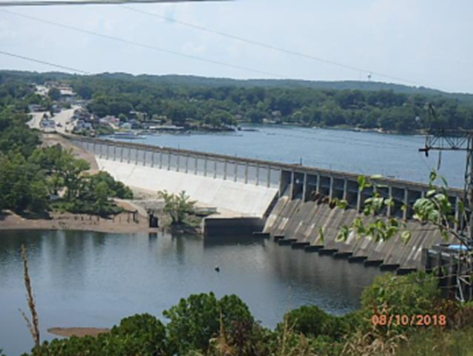
Bagnell Dam is operated and maintained by Ameren Missouri, the successor of Union Electric, under the authority of a permit issued by the Federal Energy Regulatory Commission (FERC). Ameren Missouri is also responsible for managing the lake’s shoreline and water levels. All land surrounding the lake is within the project boundary defined by FERC and is under Ameren’s management jurisdiction. Any improvements to the shoreline, including docks, bulkhead walls, boat ramps, and other structures, require permission from Ameren Missouri prior to construction and are covered under the FERC-approved Shoreline Management Plan (SMP).
When Trailhead GIS, Inc. owner Mike Pellegrino joined SAM, it marked an almost 25-year milestone where the consulting team had supported Ameren to develop and maintain the Shoreline Management System for the Lake of the Ozarks, a reservoir that provides households across Missouri with power.
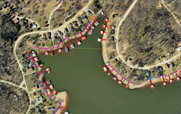
Since the late 1990s, SAM and Trailhead staff have provided the collection, development, and maintenance for digital maps and related spatial datasets. These include Orthophotos, contours, parcels and land records, and limited planimetric features. To meet FERC requirements for digital data delivery in a GIS format, SAM staff developed, hosted, deployed, and now maintains the SMS GIS components. The original intent for the system was to meet FERC requirements for a 50-year operating permit and was focused on the shoreline facilities permitting process. This includes over 50,000 shoreline facility permits along 1,150 miles of lake shoreline. With the help of SAM GIS staff, the SMO has streamlined the permitting process, leveraged the existing data to solve multiple systems of record issues, expanded users of the system, and responded to new FERC requirements, such as white foam remediation, unpermitted docks, and derelict dock identification. 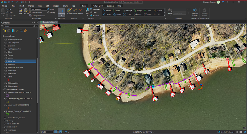
Other applications and extended SMS uses beyond the permitting process SAM built, include Adopt-the-Shoreline. Much like the Adopt-a-Highway program, the Adopt-the-Shoreline focuses on involving the local community in annual shoreline cleanup. GIS is used to assign cleanup areas and track work and trash removal. The white foam remediation project identified and tracked the removal of existing boat docks with unapproved floatation materials. The derelict dock removal program uses mobile GIS to identify old inadequate boat docks that are a hazard or have been removed. The historic properties mapping identified historic properties and ancient sites preserved under federal law. The recreation management layer lists the recreation sites available to the public and typically located within the State parks.
Over the years, SAM staff and Ameren have partnered to expand and maintain the system that serves the SMO. Through that time, as Ameren has expanded its operations to include ESRI ArcGIS Enterprise and ArcGIS Online, SAM has continued to serve as an advisor providing vision and direction and is a valued partner for the long-term maintenance of the system geodatabase.