

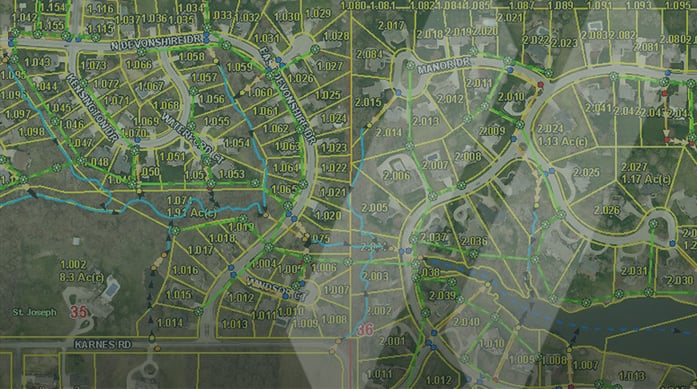
In 2019, Jefferson County, Missouri, which encompasses part of the St. Louis Metropolitan Area, faced the daunting task of updating its parcel-based Geographic Information System (GIS). The original database had been constructed several years prior, and the Department of the County Assessor’s office had begun to notice inaccuracies in the system, particularly with the mapping of parcel boundaries and road rights-of-way.
Through the Jefferson County Web map, hosted and administered by the Department of the County Assessor, county agencies and the public can access current aerial photography, parcel information, roads, floodplains, and much more. Seeing any inaccuracies calls into question the reliability of the entire database, so the GIS needed to be updated quickly and accurately. To address this issue, Jefferson County initiated the GIS Quality Control Mapping Project, which included reconstructing the parcel data layer referenced to an adjusted Public Land Survey System.
With an eye toward reliability, Jefferson County chose SAM’s GIS experts to spearhead the project. As an active user of its GIS, Jefferson County’s database had approximately 103,000 mapped parcels within the current system that had to be verified by our team.
Working closely with the Jefferson County GIS Coordinator, our team obtained various sources of survey research information, including recorded subdivision plats from the recorder’s office, existing tax maps, and aerial photography to help with the data reconstruction process. Once compiled, we used Esri technology and custom tools to process and map spatial data and ensure connectivity and accuracy. To allow the county to continue using the GIS data during the reconstruction, we staged the data delivery within predefined project areas.
Bob Boyer, Jefferson County Assessor, said, “SAM did a great job working with my staff on what the project goals were, and then working side-by-side with Jefferson County to make sure we have a quality GIS the public can trust.”
All completed GIS parcels were run through SAM’s internal quality assurance (QA) process to confirm data integrity. Applying predefined topology rules to the completed GIS data layers, our team also eliminated any overlaps or gaps within the first phase’s final data delivery. The project’s first phase took 18 months to complete and covered over 70,000 parcels from the county’s GIS.
Matt Sorensen, Director of GIS Operations at SAM, said, “With this new reconstruction of their GIS, they operate from the best, and most updated data. This helps citizens, utility companies, emergency services, and other public agencies make informed decisions and deliver better services to everyone.”
Creating an online GIS database is a foundational and worthwhile investment for local governments. It is just as important to plan for maintaining and updating the system. Visit our website to learn more about how SAM’s GIS mapping and data development capabilities or our experienced local government team can help create or manage your GIS database.