

| Carlos Montoya
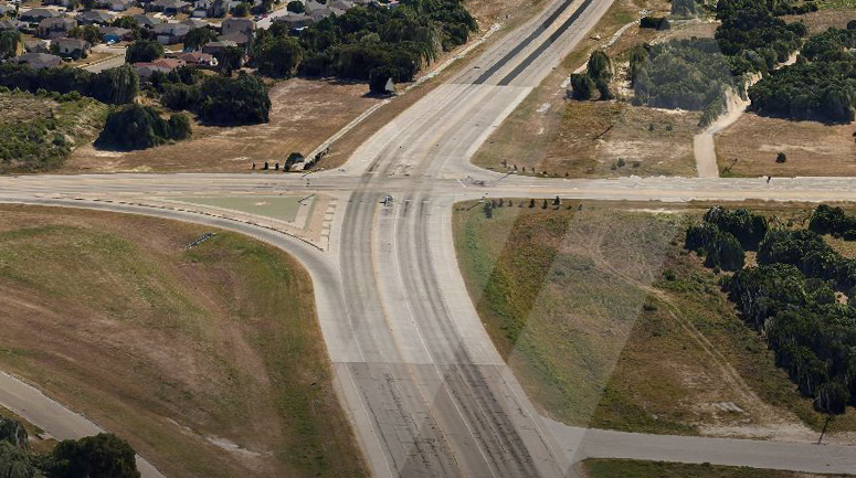
Implementation of advanced visualization tools in the early stages of design that provide clear, concise information of existing site conditions prevent costly construction plan changes, significant delays on the project schedule, possible conflicts with approved permits, and expensive construction claims. Reality modeling technology offers the opportunity to improve design and review by providing a rich 3D environment that captures all details. High-resolution 3D meshes, also known as Digital Surface Models (DSM) or digital twins, provide real-world digital context, and include advanced measurement tools. They can be easily integrated into CADD workflows, or shared by a local viewer or through the cloud. The capability to share 3D models of a small road section or an entire facility within teams over the cloud facilitates early collaboration in the review process. It allows designers, contractors, suppliers, and other groups to come together to provide contract plans that are both buildable and biddable.
Digital Twins
Digital Twins enable us to insert virtual objects and 3D structure models using detailed existing as-is conditions as context. As a result, the contractor can prepare a competitive bid using detailed design plans and specifications to calculate costs using standard construction methods, materials and techniques. Building in accordance with these plans and specifications will ensure the project is maintained in a cost-effective manner over the life of the project.
Currently, various techniques are used to collect data, including laser scans, photogrammetry with high-resolution cameras, and total stations. While photogrammetry is not a recent development, there has been notable advancement in the software for post-processing and analyzing reality meshes and integrating Geographic Information System (GIS) data into the models. Reality modeling software takes as input a set of digital photographs taken from different viewpoints, point clouds, or both to generate a high-resolution 3D mesh.
Utilizing 3D Technology
Major advances in photogrammetric 3D modeling now allow the creation of realistic 3D structures like poles and towers using 2D photographs by an automated software process. A trigonometric algorithm calculates a point cloud using the tie points, camera locations and lens data. A point cloud is a set of points in a three-dimensional space, where every point has X, Y, and Z coordinates and a color value. Feature detection algorithms are used to find planes and straight corners in the 3D geometry to create a three-dimensional polygonal geometry mesh that matches the point cloud.
Point clouds, reality meshes obtained from laser scanning, and photogrammetry techniques can advance various approaches of processing data from project sites, such as construction and earthwork estimation approaches and as-built conditions. We can enhance these applications by adopting state-of-the-art aerial platforms for data acquisition, such as UAS-based photogrammetry techniques and the latest software for creating a 3D reality mesh. This opens new possibilities for more efficient site surveying and constant updating of infrastructure for asset and facility management.
Furthermore, a photogrammetric 3D model serves as a genuine record of a 3D environment at a specific moment in time. Suppose you incorporate animation in to the time axis of the 3D model. In that case, you can display even more information into the 3D model such as the different stages of a project, downtimes, and cost. Photogrammetric 3D models continue to evolve with added data and information. They create a connection between the digital and physical world, offering a better decision-making process with a complete collection of all data in one place.
The Future of Photogrammetric 3D Modeling
Looking to the future, photogrammetric 3D modeling can be combined with other cutting-edge technology like virtual and augmented reality to perform design and constructability reviews by mimicking real people with digital characters – “avatars.” These avatars will be remotely located through the internet, navigating, observing, measuring, and discussing their design in a 3D reality model. This has the potential to enable a more collaborative environment with increased immersion into the project site and design elements, as well as eliminating costs that come with everybody meeting in the same physical space.
At SAM, we are constantly exploring innovative approaches and practical solutions for complex projects. Our 3D technology enables the development of reality models or digital twins, and reality capture for asset and facility management by using the latest in surveying and mapping techniques. Our SAM aircraft can simultaneously capture LiDAR, thermal, vertical color photography, and oblique data. We also implement advanced visualization tools such as virtual, augmented, mixed reality, and future technologies like artificial intelligence and machine learning. We facilitate data collection, modeling, and management for informed decision-making and project management.