

| Carlos Montoya
Unmanned aerial systems (UAS), more commonly called drones, have expanded sensor mobility from the ground to the air and revolutionized how utility inspections of all kinds can be done. The use of UAS has proven particularly effective for electric inspections, changing how industry leaders provide information and monitor electrical infrastructure.
UAS are able to rapidly collect a large volume of HD imagery and video, thermal, and LiDAR data. As electrical transmission and distribution systems degrade over time, physical changes of a structure often provide obvious, visible warning signs of deterioration and impending problems. These visible changes mean HD imagery and video are the most efficient way to monitor the degradation of these systems.
For assessing electrical infrastructure such as high-voltage transmission lines, pairing HD images and video with thermal and LiDAR data is ideal. Trailblazing sensors collect thermal images coupled with color (RGB) to give a clear picture of thermal anomalies for preemptive defect identification. In addition, UAS can be used to collect LiDAR data to evaluate vegetation conditions, including encroachment measurements and automated routines to identify, quantify, and analyze risk areas as they develop. LiDAR data can even be used to support vegetation growth modeling. Utilizing all of these different forms of data reduces operational costs to patrol power lines and improves service reliability for customers.
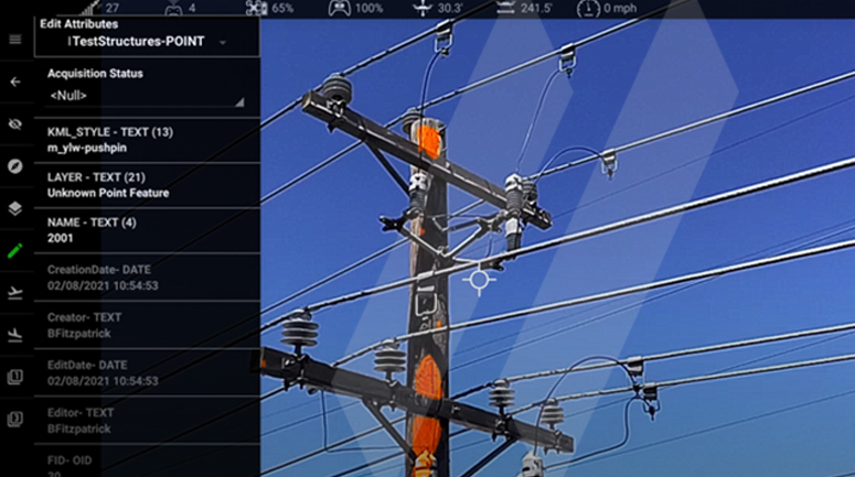
In the office, the images and LiDAR data acquired by UAS can be downloaded, analyzed, and integrated into a geodatabase. A geodatabase is a logical, single-file format for organizing spatial data such as the GPS coordinates of poles, images, direction, elevations, asset type, ID, remotely sensed data, maintenance logs and accounting information. The geodatabase can consolidate all of this data to plot operation and maintenance costs by area. Each geodatabase structure is designed based on the needs of the utility, previous models, and geographic information systems (GIS) utility models.
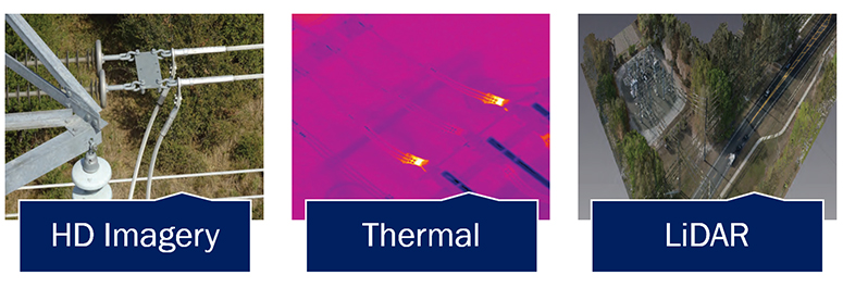
Hot Spots – Thermal imagery is used to safely and efficiently reveal thermal anomalies on high voltage distribution and transmission assets. Thermal cameras produce temperature measurements for each pixel within the image, as a result thermal anomalies are visually represented as “hot spots”. Hot spots are quickly identified and then analyzed to determine current component failures or issues that may result in costly and dangerous failures.
When designing a geodatabase, custom domains (pre-defined menus) are built for each layer (asset). Domains help simplify the editing and data management processes to make future management of the geodatabase easier. During data collection and inspection, the attribute tables maintain consistency. After all the GPS located and attributed data is validated, the collected and mapped electric data is uploaded into the utility’s geodatabase and integrated into the utility’s GIS website. Once completed, geodatabases serve as record books by locating and quantifying utility assets, tracking system maintenance, and assisting with design and emergency response.
SAM crews use a combination of these groundbreaking UAS capabilities to capture and analyze data with exceptional accuracy and turn complex data into actionable information for our clients. Recently, SAM inspected 2,400 miles of electric distribution line for an electric utility client. The inspection included visual imagery, thermal measurements and the use of LiDAR to identify vegetation encroachment. Our teams and the client tracked the project’s progress in real-time using custom mobile web mapping applications and a client-facing portal. UAS field crews logged additional information such as access restrictions and high priority notifications in the database to help plan repair operations. In total, SAM photographed, inspected and delivered 89,600 structures via a secure GIS network. As a result of this inspection, SAM identified over 53,000 defects or obsolete equipment along with other notable items such as 26,000 splices.
SAM also uses Augmented Reality (AR) and cloud computing to enhance our UAS electric inspection approach. By harnessing our AR capabilities, SAM has streamlined the collection of UAS inspection data and the management of geospatial data.
Our GIS databases, traditionally analyzed and manipulated in the office, are now accessible in the field through user portals and mobile applications through the cloud. Activities such as saving data into a hard drive, loading data on a server, correlating location and other information on assets into the GIS program, and entering field notes are now done on one cloud-based system. Our teams can integrate new inspection data directly into the asset management program while on site. UAS field crews can edit asset attribute information, such as uploading flight images that identify component defects, directly in the GIS database during an inspection.
Our UAS themselves do not just collect data while in use – they also provide information to the GIS asset management program in real-time. By connecting to the GIS program via our cloud system, a UAS can upload the images it captures in real-time to create an interactive AR experience. In this AR representation of the real-world environment, electric structures on site are enhanced by the computer-generated GIS information and overlaid on the live video captured by the UAS. Using AR in this way during UAS electric asset inspection improves cost and performance by reducing the potential for human error, facilitating communication among teams, and enabling clients to make data-driven decisions related to repair and maintenance priorities.
At SAM, we are constantly evaluating and integrating geospatial technologies that enable more efficient, cost-effective, and timely solutions. As our UAS systems increase in capability, our workflows will adapt to optimize activities such as data management, quality control, communication, progress tracking, decision-making, and product delivery.