

Across the country, many utility companies are turning to undergrounding their electric lines, especially in urban areas. Undergrounding electric lines improves customer service, makes it safer to perform maintenance on Transmission & Distribution (T&D) lines, and better protects the assets for a longer life by reducing the risks caused by natural or man-made events. However, logistically, undergrounding electric utilities is more difficult and expensive to install, which is doubly true for moving them once they’re operational. Original routing or rerouting of electric lines in urban areas poses a greater risk of disrupting other utilities. Additionally, the planning must factor in existing infrastructure, such as roads and homes, and must be precisely located and mapped for engineering design consideration. Given these factors, the quality and detail of the map created for planning and design are critical for the entire undergrounding program.
Often, SAM is the consultant that utility companies turn towards for the map creation and documentation of site conditions. That was the case for a national electric utility company looking for possibilities to route underground transmission lines within a major metropolitan area. In addition to needing an accurate map of overhead, surface, and subsurface features, they needed it fast.
Right off the bat, the short timeline posed a challenge even for our team, which is routinely accustomed to working on large-scale, complex programs on an abbreviated timeline.
SAM’s Project Manager, Carlos Montoya, Ph.D., said, “We always work to find unique solutions catered to each client’s needs. In this case, the schedule was very important to the client, which meant partial 2D mapping initially for the underground features rather than full 3D mapping on all features. Field data was collected and distributed in near real-time, allowing the client’s office technicians to start the planning process immediately.”
SAM collected attributes and mapped features into a geodatabase for each route under consideration to provide a complete overview of the alternate route options. Again, time was of the essence for this project, so several of SAM’s services collaborated to collect the spatial data, including Aerial Mapping and Subsurface Utility Engineering (SUE), for use in a Geographic Information System (GIS).
SAM performed document research, gathered existing digital maps, and worked with the area’s utility owners, municipalities, and irrigation districts. We established a baseline of prioritizing and ranking the source material, including coordinating with all the stakeholders for additional information when necessary.
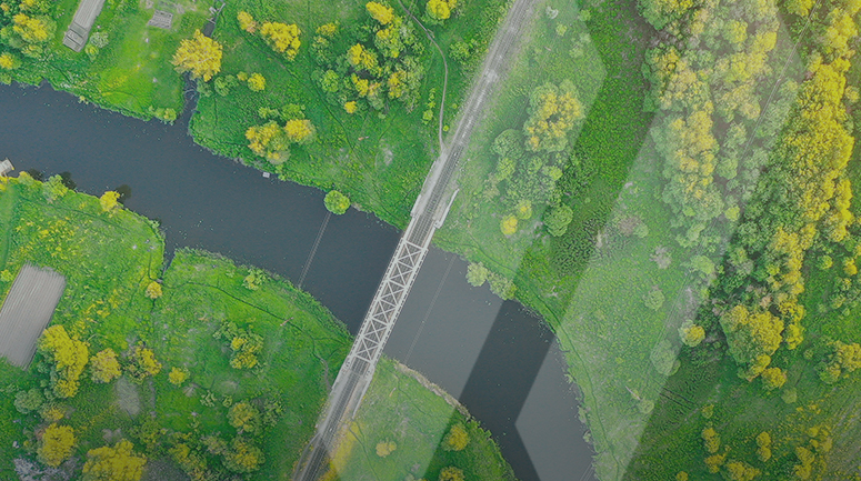
Once we had established a comprehensive view of all the utilities that might be present, it was time to verify and supplement these records. Using a combination of ground and aerial mapping methods, SAM employed a variety of remote sensing instruments to acquire spatial data for all routing possibilities. We provided underground utility mapping to verify and locate all utilities, and collected high-resolution aerial imagery and LiDAR for surface and above-the-surface features.
Our team utilized our fixed-wing aircraft, a Cessna Grand Caravan EX, equipped with a dual port platform, a RIEGL VQ-1560 II, and a 4-way oblique camera system. The platform allowed our team to collect aerial LiDAR and Orthophoto imagery for all the possible routing options, including oblique angle imagery of substations along the routes. LiDAR data, vertical, and oblique imagery in a single mission provided the base mapping required to reference the documents and map the underground utilities in the fastest, most comprehensive manner.
So, how did SAM deliver all this spatial data, in one place, in client specifications for all the different planning and design teams in near real-time?
Our customized, web-based software was the perfect option. SAM IntegrityTM is an online GIS portal that merges multiple datasets into one common operating picture. It provides our clients with a hosted GIS solution to store a large volume of spatial data for decision support, planning, and design. The software allows the user to view, edit, and query the database to support final route selection. The digital datasets are stored in a reliable and secure platform. The client deliverable is a fully attributed, spatially referenced geodatabase with an absolute accuracy that can easily migrate into operation and maintenance functions.
Thanks to our multi-service, leveraged technology approach, we were able to provide a customized solution to the client. Additionally, our national presence allowed us to draw on our specialized teams across the country to meet the staffing needs of this fast-paced schedule. The multifaceted deliverable enabled the client to design the final route more easily in a complex urban environment.
Learn more about how SAM’s innovative technology and customized solutions can help you successfully undertake complex projects on short timelines.